“879 Father Capodanno Boulevard”
Project
A Joint Project


![Tax Map - Block 3850 - 879 Fr Cap Blvd - ESL4 & ESL9 [Version 2026.01a] [3 to 2] [for Website]](https://eslholding.com/wp-content/uploads/slider/cache/f5a95dbfc48450c30d920c0310da7eaf/Tax-Map-Block-3850-879-Fr-Cap-Blvd-ESL4-ESL9-Version-2026.01a-3-to-2-for-Website.png)
Redevelopment into community facilities
This group of properties is located on beautiful Father Capodanno Boulevard on the East Shore of Staten Island, New York City – in the Midland Beach neighborhood. Directly adjacent to the Atlantic Ocean (and its Midland Beach), it offers great views of the Verrazzano-Narrows Bridge and Lower New York Bay.
Features:
• Redevelopment properties
• To be redeveloped as a community facility (an office complex with educational and health institutions)
• Design work is currently underway
Locations (property addresses):
• [“879”] Father Capodanno Blvd, Staten Island, NY 10305 – Main lot
• 877 Father Capodanno Blvd, Staten Island, NY 10305
• 875 Father Capodanno Blvd, Staten Island, NY 10305
• 871 Father Capodanno Blvd, Staten Island, NY 10305
• [N/A] Graham Blvd, Staten Island, NY 10305 [Block 3850, Lot 31]
• 21 Graham Blvd, Staten Island, NY 10305
• [N/A] Quincy Ave, Staten Island, NY 10305 [Block 3850, Lot 1]
• 10 Sioux St, Staten Island, NY 10305
• 12 Sioux St, Staten Island, NY 10305
• 14 Sioux St, Staten Island, NY 10305
• 18 Sioux St, Staten Island, NY 10305
• 22 Sioux St, Staten Island, NY 10305
• [N/A] Quincy Ave, Staten Island, NY 10305 [Block 3850, Lot 4]
Developer: ESL4 Properties LLC and ESL9 Properties LLC – in association with ESL Holding LLC and Konus Development LLC
Status: In development
Estimated completion date (ECD): 2029
-
Block & Lots / Sizes
-
Zoning
-
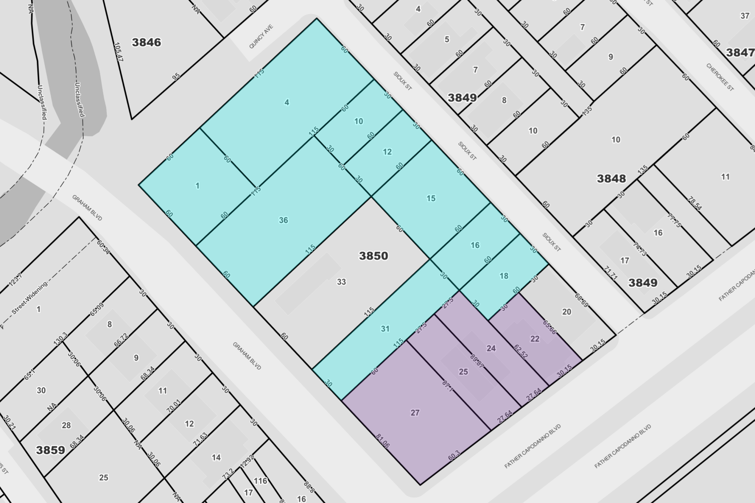
Tax Map
Block 3850:
• Lot 27 ([“879”] Father Capodanno Blvd, Staten Island, NY 10305) | Frontage: 60.3 ft / Depth: 81.06 ft / Area: 5,045 sq ft [#1]
• Lot 25 (877 Father Capodanno Blvd, Staten Island, NY 10305) | Frontage: 27.64 ft / Depth: 87 ft / Area: 2,430 sq ft [#2]
• Lot 24 (875 Father Capodanno Blvd, Staten Island, NY 10305) | Frontage: 27.64 ft / Depth: 92 ft / Area: 2,500 sq ft [#3]
• Lot 22 (871 Father Capodanno Blvd, Staten Island, NY 10305) | Frontage: 30 ft / Depth: 65 ft / Area: 1,923 sq ft [#4]
• Lot 31 ([N/A] Graham Blvd, Staten Island, NY 10305) | Frontage: 30 ft / Depth: 115 ft / Area: 3,450 sq ft [#5]
• Lot 36 (21 Graham Blvd, Staten Island, NY 10305) | Frontage: 60 ft / Depth: 115 ft / Area: 6,900 sq ft [#6]
• Lot 1 ([N/A] Quincy Ave, Staten Island, NY 10305) | Frontage: 60 ft / Depth: 60 ft / Area: 3,600 sq ft [#7]
• Lot 18 (10 Sioux St, Staten Island, NY 10305) | Frontage: 30 ft / Depth: 60 ft / Area: 1,800 sq ft [#8]
• Lot 16 (12 Sioux St, Staten Island, NY 10305) | Frontage: 30 ft / Depth: 60 ft / Area: 1,800 sq ft [#9]
• Lot 15 (14 Sioux St, Staten Island, NY 10305) | Frontage: 60 ft / Depth: 60 ft / Area: 3,600 sq ft [#10]
• Lot 12 (18 Sioux St, Staten Island, NY 10305) | Frontage: 30 ft / Depth: 60 ft / Area: 1,800 sq ft [#11]
• Lot 10 (22 Sioux St, Staten Island, NY 10305) | Frontage: 30 ft / Depth: 60 ft / Area: 1,800 sq ft [#12]
• Lot 4 ([N/A] Quincy Ave, Staten Island, NY 10305) | Frontage: 115 ft / Depth: 60 ft / Area: 6,900 sq ft [#13]
Total Lot Area (13 lots) – 43,548 sq ft
Zoning Districts:
• R3-2 districts (which are general residence districts that allow a variety of housing types, including low-rise attached houses, small multifamily apartment houses, and detached and semi-detached one- and two-family residences; it is the lowest density zoning district in which multiple dwellings are permitted) – all lots
• C1-3 districts (which are commercial overlays mapped within residence districts along streets that serve local retail needs) – only Lot 27 ([“879”] Father Capodanno Blvd), Lot 25 (877 Father Capodanno Blvd), Lot 24 (875 Father Capodanno Blvd), and Lot 22 (871 Father Capodanno Blvd)
Sources:
• Maps – New York City Department of Finance (NYC DOF), Property Information Portal: propertyinformationportal.nyc.gov
• Ownership Information – Office of the Richmond County Clerk, Land Documents Search: richmondcountyclerk.com/Search/SearchIndex
Last reviewed/updated: January 21, 2026